INTRODUCING
BOOKINGS ON WIKICAMPS
North East Rail Trail - Tongarah
 Point of Interest
Description
The Rotary Club as constructed a toilet with a water tank at the car park here at Tonganah which is the lowest point of the 26km rail trail. From here you can ride either west to Scottsdale or East to Tulendeena. The surface is medium gravel with patches of blue metal so can be mildly rough.
Tonganah to Scottsdale(10km)
From Scottsdale rail station car park, head south out of town crossing Ellenor and King Streets.
The trail ascends through picturesque farmland and bushland then behind the old timber mill at Lings Siding and crossing the Tasman Hwy twice then over the Great Forester River.
Tonganah to Tulendeena (Billycock Hill) (16km)
It's a gentle but steady climb almost all the way from Tonganah up to the former station of Tulendeena at the top of Billycock Hill.
At the start the trail goes off the rail corridor for a short distance to divert around some old clay mining pits that were dug after the line beyond Tonganah was removed. Stay on the signposted trail through this area.
This section of the rail trail winds through beautiful tall forests with spectacular tree fern-lined cuttings and huge embankments across gullies, well away from any roads. As it climbs, the trail provides views through the trees to the farmland far below. To gain height, the trail winds back on itself in a huge S-curve. Heading uphill, in the middle of the S-curve, the trail you have been on is far below on your left while the trail to come is above you on your right. At the highest point, you can look out to Bass Strait and on clear days see the mountain peaks on Flinders Island.
There are shelter sheds at the old station sites at Trewalla, Kamona and Tulendeena. Water is available at Kamona.
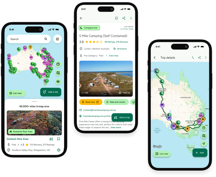
Find this site and more on WikiCamps
Take the ultimate camping companion on your next trip, with these great features:
![]() Explore more than 60,000 sites across Australia with detailed site information at your fingertips
Explore more than 60,000 sites across Australia with detailed site information at your fingertips
![]() Stay in the know with exclusive, insightful reviews from fellow travellers
Stay in the know with exclusive, insightful reviews from fellow travellers
![]() Map journeys, plan your route, and gauge your fuel spend with Trip Planner
Map journeys, plan your route, and gauge your fuel spend with Trip Planner
![]() No signal? No worries! Use offline mode to travel anywhere with WikiCamps
No signal? No worries! Use offline mode to travel anywhere with WikiCamps
![]() Add sites to your collections, search with intuitive filters, and so much more...
Add sites to your collections, search with intuitive filters, and so much more...
Get WikiCamps now!
Download WikiCamps from the App Store on your device.

