INTRODUCING
BOOKINGS ON WIKICAMPS
Algebuckina North No Public Access West Of Bridge
 Day Use Area
Description
Camping at Algebuckina is restricted to the area of the main waterhole east of the Oodnadatta Track. Ensure gate remains closed.
To preserve the area:
No 4wd access on the old Ghan line or bush tracks.
No vehicle or motorbike access west the bridge.
No hang gliding or parachuting from the bridge.
No fossicking.
If visiting the ruins all vehicles must be parked within 20m of the Oodnadatta Track and visitors must continue on foot.
Do not leave human waste, female hygiene products exposed. Please take with you or use a spade and bury 30cm.
This area is part of the Neales River catchment and offers refuge to wildlife and livestock.
Please respect the landscape.
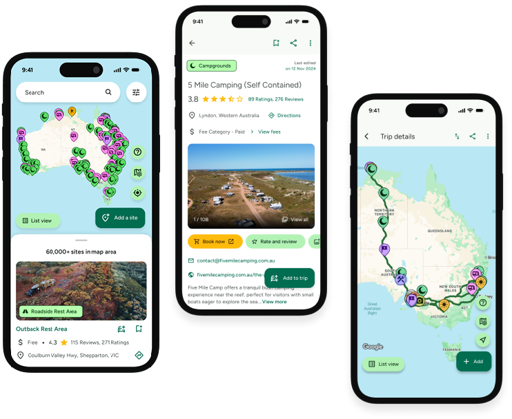
Find this site and more on WikiCamps
Take the ultimate camping companion on your next trip, with these great features:
![]() Explore more than 60,000 sites across Australia with detailed site information at your fingertips
Explore more than 60,000 sites across Australia with detailed site information at your fingertips
![]() Stay in the know with exclusive, insightful reviews from fellow travellers
Stay in the know with exclusive, insightful reviews from fellow travellers
![]() Map journeys, plan your route, and gauge your fuel spend with Trip Planner
Map journeys, plan your route, and gauge your fuel spend with Trip Planner
![]() No signal? No worries! Use offline mode to travel anywhere with WikiCamps
No signal? No worries! Use offline mode to travel anywhere with WikiCamps
![]() Add sites to your collections, search with intuitive filters, and so much more...
Add sites to your collections, search with intuitive filters, and so much more...
Get WikiCamps now!
Download WikiCamps from the App Store on your device.

